- Home
- Using Location Data (Map)
- Using Location Logs
- Configuring Altitude (Barometer)/Depth Log Application Settings
Font size
- S
- M
- L
Configuring Altitude (Barometer)/Depth Log Application Settings
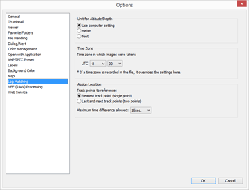
The setting screen is displayed when you click  on the Toolbar and select [Log Matching].
 on the Toolbar and select [Log Matching].
You can set the time zone in which an altitude (barometer)/depth log was recorded, and select the method by which to assign altitude (barometer)/depth data to the location log.

After making the settings, click [OK] to apply them.
Items on the setting screen
Unit for Altitude/Depth
The unit used when matching altitude (barometer) and depth logs and location data can be selected.
- By default, [Use computer setting] is selected.
- You can select either [meter] or [feet] as the unit used in the altitude (barometer)/depth graph area. This selection affects the unit displayed in the graph. The original unit will remain in the actual output logs.
Time Zone
Click  to set the time difference between Coordinated Universal Time (UTC) and the time zone of the region where the altitude (barometer)/depth log was recorded.
 to set the time difference between Coordinated Universal Time (UTC) and the time zone of the region where the altitude (barometer)/depth log was recorded.
By default, time zone is set based on [Date & Time] / [Time Zone] on Windows, the [Date & Time] / [Time Zone] on Mac OS.
You can check which time zone the recording location belongs to by referring to the OS setting screen.
Specify the time zone that you want to use.
Assign Location
In [Maximum time difference allowed:], set how altitude (barometer)/depth data is assigned to the location log, based on the track points recorded in the altitude (barometer)/depth log.
[Nearest track point (single point)]
The altitude (barometer)/depth data of a track point in the altitude (barometer)/depth log is assigned to the closest corresponding track point in the location log.
[Last and next track points (two points)]
The altitude (barometer)/depth data assigned to the location log is estimated based on the difference between the recording time of a track point in the location log and the recording times of the two adjacent track points in the altitude (barometer)/depth log.
For details about how altitude (barometer)/depth data is assigned, refer to "Assigning altitude (barometer) and depth data".
[Maximum time difference allowed:]
Sets the allowable time range for the referenced altitude (barometer)/depth data.
The altitude (barometer)/depth data is assigned to the location log if the difference between the recording times of the corresponding track points in the location log and altitude (barometer)/depth log is within the specified range.
