
- Home
- Using Location Data (Map)
- Using Location Logs
- Merging Altitude (Barometer) and Depth Logs with Location Log
Font size
- S
- M
- L
Merging Altitude (Barometer) and Depth Logs with Location Log
You can merge altitude (barometer)/depth logs saved by a Nikon digital camera into a location log saved by a camera, mobile phone, or satellite navigation system receiver that can obtain location data.
Before performing this procedure, import the location, altitude (barometer), and depth log files to your computer, or save them on a memory card and connect it to your computer using a card reader.
For details about how to save and transfer location, altitude (barometer), and depth log files, refer to the user manual supplied with your camera, mobile phone, or satellite navigation system receiver.
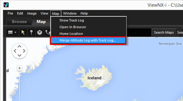
- Select [Merge Altitude Log with Track Log...] in the [Map] menu.
 The [Merge Altitude Log with Track Log] screen is displayed. The screen is divided into the map area, altitude (barometer)/depth graph area, location log file display area, and altitude (barometer)/depth log file list.
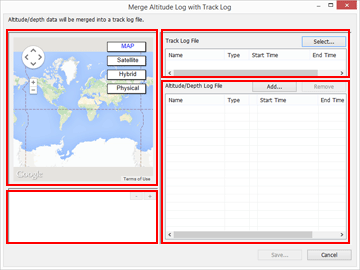
- Click [Select...].
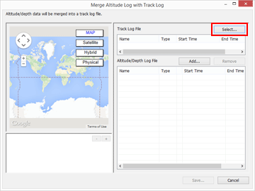 A screen for selecting a location log file from your computer or card reader is displayed.You can only select only one location log file at a time.
- Select the location log file that you want to load, and click [Open].
The location log file is loaded on the [Merge Altitude Log with Track Log] screen.The location log file display area on the [Merge Altitude Log with Track Log] screen shows the file names, file formats, and recording start/end times of the loaded location log files.
- Click [Add...].
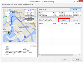 A screen for selecting depth and altitude (barometer) log files from your computer or card reader is displayed.You can select up to ten altitude (barometer) or depth log files at a time.Place a check mark in the checkbox to the left of an added altitude (barometer) or depth log file to select it as a candidate for merging with the location log file.
- When altitude (barometer)/depth logs are selected with a check mark and their recording periods are included in the recording period of the location log, the altitude (barometer)/depth data is assigned to the location log file.
- For details about the settings, refer to "Configuring Altitude (Barometer)/Depth Log Application Settings".
- Click [Save...].
A screen for setting the save destination and file name is displayed.By default, a file name consisting of the location log name with an appended sequential number is entered. When saved, the altitude (barometer)/depth logs are merged with the location log, and the [Merge Altitude Log with Track Log]screen closes.If you click [Cancel], the altitude (barometer)/depth logs are not merged with the location log, and the [Merge Altitude Log with Track Log] screen closes.
Loading location log files
You can load only one location log file at a time.
- To load an additional location log file, click [Add...]. The loaded location log files are displayed in the location log file display area.
- When you load a location log file, the location data based on the contents of that location log is displayed in the map area. Altitude (barometer) and depth data is displayed in the altitude (barometer)/depth graph area only if the location log already contains altitude (barometer) and depth data.
Loading altitude (barometer) and depth log files
You can load up to ten altitude (barometer) and depth log files and merge them with the location log file.
- To load additional altitude (barometer) and depth log files, click [Add...]. The loaded altitude (barometer) and depth log files are displayed in the altitude (barometer)/depth log file list.
- The altitude (barometer) and depth data is assigned to the location log file based on the contents of all log files in the altitude (barometer)/depth log file list.
- When the recording periods of multiple altitude (barometer) or depth log files overlap:
- If the start times are different for the overlapping recording periods, the data from the file with the later start time takes priority and is applied.
- If the start times are the same, the data from the file with the longer recording period takes priority and is applied.
- If the location log already contains altitude (barometer) or depth data, it is overwritten with the newly added altitude (barometer) and depth data.
- When an altitude (barometer) or depth log file is selected with a check mark in the altitude (barometer)/depth log file list, a graph showing the altitude (barometer)/depth data is displayed in the altitude (barometer)/depth graph area.
- To remove a loaded altitude (barometer) or depth log file from the list, select the altitude (barometer) or depth log file and click [Remove].
Assigning altitude (barometer) and depth data
Altitude (barometer) and depth data can be assigned to a location log file in the two ways described below.
- [Nearest track point (single point)]
- The altitude (barometer)/depth data of a track point in the altitude (barometer)/depth log is assigned to the closest corresponding track point in the location log.
- Example:
- Suppose that track points 1 and 2 are in the location log, which records a track point every minute, and track points A, B, C, and D are in the altitude (barometer) or depth log, which records a track point every 30 seconds.
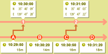
- Track point 1 is assigned the altitude (barometer) or depth data of track point A, and track point 2 is assigned the altitude (barometer) or depth data of track point C.
- [Last and next track points (two points)]
- The altitude (barometer)/depth data assigned to the location log is estimated based on the difference between the recording time of a track point in the location log and the recording times of the two adjacent track points in the altitude (barometer)/depth log.
- Example:
- Suppose that track points 1 and 2 are in the location log, which records a track point every minute, and track points A, B, C, and D are in the altitude (barometer) or depth log, which records a track point every 30 seconds.
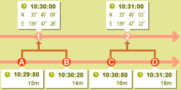
- Track point 1 is assigned altitude (barometer)/depth data that is calculated based on the data and time differences of track points A and B, and track point 2 is assigned altitude (barometer)/depth data that is calculated based on the data and time differences of track points C and D.
You can set how to assign the altitude (barometer) and depth data on the setting screen. For details about the setting screen, refer to "Configuring Altitude (Barometer)/Depth Log Application Settings".
About time zones
The time zone setting is referenced when assigning altitude (barometer) and depth data.
- The recording time of altitude (barometer)/depth logs is often based on Coordinated Universal Time (UTC), which is the world time standard based on astronomical observations. The UTC time offsets used around the world are established for each region, and regions that share the same time offset are called time zones.
- The time zone to use can be specified on the setting screen. For details about the setting screen, refer to "Configuring Altitude (Barometer)/Depth Log Application Settings".