- Home
- Using Location Data (Map)
- Using Location Logs
- Configuring Location Log Application Settings
Font size
- S
- M
- L
Configuring Location Log Application Settings
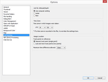
The setting screen is displayed when you click  on the Toolbar and select [Log Matching].
 on the Toolbar and select [Log Matching].
You can set the time zone in which an image was taken and choose the method by which to assign shooting location information to the image.

After making the settings, click [OK] to apply them.
Items of setting screen
Unit for Altitude/Depth
The unit used in the map can be selected.
- By default, [Use computer setting] is selected.
- You can select either [meter] or [feet] as the unit used in the altitude (barometer)/depth graph area. This selection affects the unit displayed in the graph. The original unit will remain in the actual output logs.
Time Zone
Time zone in which images were taken:
Click  to set time differences between Coordinated Universal Time (UTC) and time zone of shooting location.
 to set time differences between Coordinated Universal Time (UTC) and time zone of shooting location.
- By default, time zone is set based on [Date & Time] / [Time Zone] on Windows, the [Date & Time] / [Time Zone] on Mac OS.
- You can check which time zone the shooting location belongs to by referring to the OS screen settings.
- When [Time Zone and Date] is embedded in the metadata of the image, the time zone set for [Time Zone and Date] is applied, regardless of the setting on this setting screen.
- [Time Zone and Date] is the metadata containing information on the time zone in which the image was taken.
- If [Time Zone and Date] information is not embedded in the metadata of the image, the shooting date and time differences set in this screen are applied.
Assign Location
In [Track points to reference:], set how to assign location data to images using the track points recorded in the location log.
If the location log contains altitude (satellite navigation system) data, that data is also assigned to images.
[Nearest track point (single point)]
The location information of the track point closest to the time the image was taken is applied.
[Last and next track points (two points)]
Based on the location information logged for 2 adjacent track points, the location information of the image is estimated by its shooting time.
For details on the allocation method, refer to "Adding Location Data Based on Location Log".
- Related item
- Using Location Logs
